

Winter 2016: A Meteorologist’s Perspective
February 19, 2016
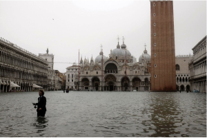
Last month, historic Blizzard Jonas stormed through the East Coast, leaving New Jersey residents immersed in over two feet of snow. As we steadily approach the core of winter, professional meteorologists recommend bracing ourselves for a wild finish to an already unpredictable season.
Brian Marmo, the Lead Long Range Meteorologist at WeatherWorks, a certified meteorological company based in Hackettstown, New Jersey sat down with The Gothic Times to give an expert’s take on how the rest of winter will turn out.
“With an active pattern expected for the rest of the winter, another good snowstorm (12”+) is possible before it is all said and done,” Marmo said.
Typically, if a snow storm hits with over one foot of snow, New Jersey enters into a State of Emergency; a formal declaration made by the governor advising residents to stay in their homes, and avoid driving. It also leads to classes being cancelled, and people being out of work for days.
Angela Nieves, 22, said, “This is my last semester before I graduate, so I’m on a tight schedule. If there’s another snowstorm and classes are cancelled it’s going to be harder to keep up.”
When it comes to predicting the rest of winter, Marmo said, “Forecasting a shift in the pattern is often quite difficult to do well in advance. We were confident it was going to start warm, but turn more seasonable for the second half of winter. I think we will definitely have additional days that are quite warm. But I also think it will be very cold at times too. The very strong El Niño will definitely be a major player.”
El Niño is described as the abnormal warming of sea surface temperatures. Brett Anderson, a senior meteorologist for AccuWeather.com said, “Confidence continues to grow that this El Niño will be one of the stronger El Niño’s over the past 50 years. El Niño typically reaches its peak during the December through February period.” Although a strong El Niño would mean a lot of rain in areas such as California, for New Jersey it could potentially cause a lot of snow. Anderson added, “The strongest El Niño on record since the beginning of the 20th century occurred during 1997-98.” This year’s El Niño will go down as the strongest since then.
Anderson and Marmo have noticed an inconsistent weather pattern this year. One week, the state is buried in snow, and the next it is 60 degrees outside. Marmo said, “It has certainly been a fascinating winter. Last year we were struck under a large upper trough of low pressure which allowed frigid air to flood down from the Arctic. February of last year was one of the coldest on record.”
On the other hand, meteorologists recorded this past December as the warmest ever. Marmo said, “During December the polar vortex was very strong, which locked the arctic air up in the polar region.” The polar vortex’s strong hold prevented any cold air from getting into our region. However, “The weakening of the polar vortex in January resulted in colder air spilling down to the Northeast.” The polar vortex’s weakening as the winter progresses explains the much colder January we had, matched with the record-breaking blizzard that raged through the state.
For more information about the science behind meteorology, and insight into the profession of a meteorologist, visit www.weatherworksinc.com